Urban Geoinformatics Lab
@HFT Stuttgart
(or Vote for new group name)
A research group introduction
here ....
The research projects at HFT Stuttgart (University of Applied Sciences Stuttgart).
Our Applications
Research Short Introduction ....
Our Publication
Our Publication ...
2020
2019
Santhanavanich, T., Wuerstle, P., Silberer, J., Loidl, V., Rodrigues, P., and Coors, V.
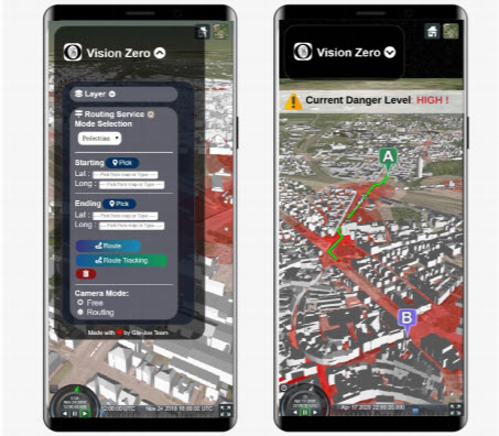
3D SAFE ROUTING NAVIGATION APPLICATION FOR PEDESTRIANS AND CYCLISTS BASED ON OPEN SOURCE TOOLS
CityGML SensorThings API Open Geospatial Consortium pgRoutingISPRS Ann. Photogramm. Remote Sens. Spatial Inf. Sci., VI-4/W2-2020, 143–147, https://doi.org/10.5194/isprs-annals-VI-4-W2-2020-143-2020
Santhanavanich, T., Wuerstle, P., Silberer, J., Loidl, V., Rodrigues, P., and Coors, V.
3D SAFE ROUTING NAVIGATION APPLICATION FOR PEDESTRIANS AND CYCLISTS BASED ON OPEN SOURCE TOOLS
CityGML SensorThings API Open Geospatial Consortium pgRouting WarningISPRS Ann. Photogramm. Remote Sens. Spatial Inf. Sci., VI-4/W2-2020, 143–147, https://doi.org/10.5194/isprs-annals-VI-4-W2-2020-143-2020
Santhanavanich, T., Wuerstle, P., Silberer, J., Loidl, V., Rodrigues, P., and Coors, V.
3D SAFE ROUTING NAVIGATION APPLICATION FOR PEDESTRIANS AND CYCLISTS BASED ON OPEN SOURCE TOOLS
CityGML
SensorThings API
Open Geospatial Consortium
pgRouting
Warning
ISPRS Ann. Photogramm. Remote Sens. Spatial Inf. Sci.,
VI-4/W2-2020, 143–147, https://doi.org/10.5194/isprs-annals-VI-4-W2-2020-143-2020
PDF BIB Link
@article{santhanavanich20203d,
                  title={3D SAFE ROUTING NAVIGATION APPLICATION FOR PEDESTRIANS AND CYCLISTS BASED ON OPEN SOURCE TOOLS.},
                  author={Santhanavanich, T and Wuerstle, P and Silberer, J and Loidl, V and Rodrigues, P and Coors, V},
                  journal={ISPRS Annals of Photogrammetry, Remote Sensing \& Spatial Information Sciences},
                  volume={6},
                  year={2020}
                }
              }